Weather Forum
»
Australia Weather
»
SEQ and NE NSW
»
SE QLD and NE NSW - Day to Day Weather
Rank: Newbie
Groups: Registered
Joined: 23/08/2019(UTC) Posts: 9  Location: Burrum Heads Thanks: 20 times
Was thanked: 26 time(s) in 8 post(s)
|
Originally Posted by: retired weather man  I update my station figures every 10 days and so far this month my station is running at 0.6C below average. This is indicated by the -6.00 circled on the RHS of the page. Also circled are the two " heatwave " days where luckily we missed out being right next to Moreton Bay. The northerly flow over those 2 days is actually onshore here, so relatively cool.  Pretty cool here over the last couple of days too RWM. Some distant rumbles now with a small, meaty looking cell heading for Howard. I might get a smidge tonight.
|
 6 users thanked Pharbelle for this useful post.
|
|
|
|
Rank: Advanced Member
Groups: Registered
Joined: 25/08/2019(UTC) Posts: 1,839 Location: Ferny Grove Thanks: 985 times
Was thanked: 856 time(s) in 419 post(s)
|
|
|
4 users thanked Falling_Droplet for this useful post.
|
|
|
|
Rank: Advanced Member
Groups: Registered
Joined: 21/08/2019(UTC) Posts: 182 Location: Wynnum North Thanks: 656 times
Was thanked: 381 time(s) in 167 post(s)
|
WYNNUM NORTH ( 27.4S 153.2E ) - WEATHER
DATE....11 OCT 2019 TIME....0730
CURRENT TEMPERATURE...17.1C
CURRENT HUMIDITY........73%
CURRENT DEW POINT.......12C
CURRENT WIND DIR/SPEED...SSE 8Kph
CURRENT VISIBILITY.....25KM
CURRENT MSL PRESSURE...1019.1Hpa
CURRENT CLOUD..........2/8 Cu, 1/8 Cb ( to N ), 6/8 Sc.
CURRENT WEATHER......Distant showers
RAIN SINCE 0900 THURSDAY..0.0mm
SUMMARY LAST 24 HOURS
YESTERDAY'S MAX TEMP. .......24.1C
THIS MORNING'S MIN TEMP......12.2C
PAST 24 HOURS TEMP ANOMALY..-2.75C
THIS MORNING'S GRASS MIN.....12.1C
AVERAGE 24 HOUR DEW POINT......12C
AVERAGE 24 HOUR MSLP........1018.9Hpa
MAX WIND GUST LAST 24 HOURS....E 36Kph at 1124
PAST 24 HR SIGNIFICANT WEATHER..Smoke haze, showers developing to distant north. |
Wyn Nth 2020-Jan165, |
6 users thanked retired weather man for this useful post.
|
|
|
|
Rank: Advanced Member
Groups: Registered
Joined: 25/08/2019(UTC) Posts: 1,839 Location: Ferny Grove Thanks: 985 times
Was thanked: 856 time(s) in 419 post(s)
|
Ferny Grove Weather
Date: 11 Oct 2019
Time: 7:55 AM
Min Temp since 9am yesterday: 12.1 C
Max Temp since 9am yesterday: 25.1 C
Min Ground Temp: 9.7 C
Rain since 9am yesterday: 0 mm
Temperature: 18.4 C
Relative Humidity: 57 %
Dew Point: 9.8 C
MSL Pressure: 1018.7 hPa
Wind Speed: 5 kph - light air
Wind Direction: S
Present Weather: State of sky generally unchanged during preceding hour
Visibility: - 20km
Cloud Cover: 6/8
Ground State: Ground dry
Notes of yesterday weather - 10/10/19: Partly cloudy with cu, sc and ac clouds. Smoke haze. Fluctuating temperature from mid morning to mid afternoon. Dew point was generally stable and near average and moderately low in the some of the early hours, the morning and afternoon, before slowly rising from late afternoon and stable in the late evening close to average. Variable relative humidity but near average in the afternoon and evening. Light WSW to SSW winds early, SSW to SE in the morning, SE to ENE from mid-morning, SSE to ESE in the late afternoon and SSW to ESE in the evening.
Today: Light shower at about 12:30 am (no measurable rainfall). Dew point have been near average, while falling slowly today and have been rising in the last hour. Relative humidity have been moderately low. Light and variable winds at times today and have became S to SW in the last hour.
|
|
5 users thanked Falling_Droplet for this useful post.
|
|
|
|
Rank: Advanced Member
Groups: Registered
Joined: 21/08/2019(UTC) Posts: 182 Location: Wynnum North Thanks: 656 times
Was thanked: 381 time(s) in 167 post(s)
|
WYNNUM NORTH ( 27.4S 153.2E ) - WEATHER
DATE....12 OCT 2019 TIME....0900
CURRENT TEMPERATURE...12.7C
CURRENT HUMIDITY........93%
CURRENT DEW POINT.......12C
CURRENT WIND DIR/SPEED...W 14Kph
CURRENT VISIBILITY.....10KM
CURRENT MSL PRESSURE...1015.0Hpa
CURRENT CLOUD..........3/8 St, 2/8 Cu, 8/8 As..
CURRENT WEATHER......Slight continuous rain
RAIN SINCE 0900 FRIDAY..53.6mm
SUMMARY LAST 24 HOURS
YESTERDAY'S MAX TEMP. .......23.6C
THIS MORNING'S MIN TEMP......12.6C
PAST 24 HOURS TEMP ANOMALY..-2.80C
THIS MORNING'S GRASS MIN.....12.6C
AVERAGE 24 HOUR DEW POINT......13C
AVERAGE 24 HOUR MSLP........1015.9Hpa
MAX WIND GUST LAST 24 HOURS....E 29Kph at 1306
PAST 24 HR SIGNIFICANT WEATHER..Thunderstorms from late Friday afternoon and into the evening.
Slight showers and rain areas overnight, heavier showers and rain areas early morning, easing to slight rain by 0900. |
Wyn Nth 2020-Jan165, |
5 users thanked retired weather man for this useful post.
|
|
|
|
Rank: Advanced Member
Groups: Registered
Joined: 21/08/2019(UTC) Posts: 182 Location: Wynnum North Thanks: 656 times
Was thanked: 381 time(s) in 167 post(s)
|
WYNNUM NORTH ( 27.4S 153.2E ) - WEATHER
DATE....13 OCT 2019 TIME....0730
CURRENT TEMPERATURE...17.2C
CURRENT HUMIDITY........72%
CURRENT DEW POINT.......12C
CURRENT WIND DIR/SPEED...WSW 19Kph
CURRENT VISIBILITY.....40KM
CURRENT MSL PRESSURE...1017.8Hpa
CURRENT CLOUD..........Nil.
CURRENT WEATHER......No significant weather
RAIN SINCE 0900 SATURDAY...6.6mm
SUMMARY LAST 24 HOURS
YESTERDAY'S MAX TEMP. .......19.8C
THIS MORNING'S MIN TEMP......10.9C
PAST 24 HOURS TEMP ANOMALY..-5.55C
THIS MORNING'S GRASS MIN......9.9C
AVERAGE 24 HOUR DEW POINT......11C
AVERAGE 24 HOUR MSLP........1014.6Hpa
MAX WIND GUST LAST 24 HOURS....W 30Kph at 0917
PAST 24 HR SIGNIFICANT WEATHER..Showers and rain eased during Saturday morning, cloud cleared during the afternoon to cloudless conditions. |
Wyn Nth 2020-Jan165, |
5 users thanked retired weather man for this useful post.
|
|
|
|
Rank: Advanced Member
Groups: Registered
Joined: 25/08/2019(UTC) Posts: 1,839 Location: Ferny Grove Thanks: 985 times
Was thanked: 856 time(s) in 419 post(s)
|
Ferny Grove Weather
Date: 13 Oct 2019
Time: 9:00 AM
Min Temp since 9am yesterday: 10.4 C
Max Temp since 9am yesterday: 21.3 C
Min Ground Temp: 8.9 C
Rain since 9am yesterday: 1.2 mm
Temperature: 20.8 C
Relative Humidity: 45 %
Dew Point: 8.5 C
MSL Pressure: 1017.8 hPa
Wind Speed: 9 kph - light breeze
Wind Direction: SSW
Present Weather: No cloud development observed
Visibility: 40km or more - Excellent Visibility
Cloud Cover: 0/8
Ground State: Ground dry
Notes of yesterday weather - 12/10/19: Light showers and rain at times from 4 am, brief heavy falls at 7am, easing at 9am, returning in the late morning and clearing at midday. Cloudy with cu, sc and as clouds clearing at midday with some cu and ac clouds. Sluggish and near average temperature early before falling after sunrise. The minimum temperature (11.8 C) was reached at 8:41 am before the temperature rose. In the late morning the temperature stabilised before rising in the afternoon. Below average maximum temperature and was a cool day. A cool evening with the temperature falling below the minimum temperature that occurred the morning. Stable and near average dew point early before falling from sunrise before stabilsing during later in the morning and then rose through to midday. In the afternoon the dew point fell and became stable and moderately low though to the evening. Relative humidity was stable and high from early falling in the afternoon and became near average from the afternoon. Light winds were generally WSW to SSW winds becoming light and variable early, WSW to SSW from 6 am, and slightly gusty W to SW light winds from mid-morning. Winds were S to SE in the late morning then WSW to S in the afternoon, SSE in late afternoon and became calm in the evening except for some S to SW winds.
Today: In the early hours the temperature was stable before rising with sunrise. A cool morning. The temperature at 9 am was 20.8 C and was slightly below the maximum since 9am yesterday ( observed at 2:52 pm). Moderately low and stable dew point early today before rose slightly in the early morning and is now near average. Relative humidity was near average overnight and moderately low during today. Relative humidity was stable for several hours in the early hours of today. Calm winds became light WSW to SSW since 4 am.
Event total: 27.9 mm (monthly total of 28.6 mm is 42.5% of the long term average and 66% of the long term median). |
|
4 users thanked Falling_Droplet for this useful post.
|
|
|
|
Rank: Advanced Member
Groups: Registered
Joined: 13/09/2019(UTC)
Posts: 118
Location: Caboolture (the next Las Vegas!)
Thanks: 215 times
Was thanked: 297 time(s) in 100 post(s)
|
Bit of an average kind of day today and it maxed out at 25 degrees. Still cool for October.
|
5 users thanked DelBoy for this useful post.
|
|
|
|
Rank: Advanced Member
Groups: Registered
Joined: 25/08/2019(UTC) Posts: 1,839 Location: Ferny Grove Thanks: 985 times
Was thanked: 856 time(s) in 419 post(s)
|
Near average temperature today but was a little variable. Dew point became moderately low and falling slowly before rising in the afternoon and is now stable and near average. Moderately low relative humidity today and a little variable in the afternoon. Light SSW to W winds, became E to SE in the afternoon, S to SE tonight and is now calm. Last 24 hours: 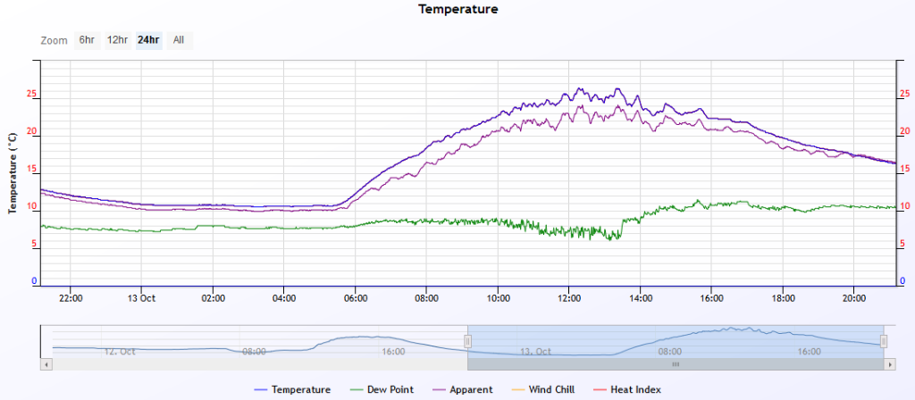   |
|
5 users thanked Falling_Droplet for this useful post.
|
|
|
|
Rank: Advanced Member
Groups: Registered
Joined: 21/08/2019(UTC) Posts: 182 Location: Wynnum North Thanks: 656 times
Was thanked: 381 time(s) in 167 post(s)
|
WYNNUM NORTH ( 27.4S 153.2E ) - WEATHER
DATE....14 OCT 2019 TIME....0725
CURRENT TEMPERATURE...18.1C
CURRENT HUMIDITY........76%
CURRENT DEW POINT.......14C
CURRENT WIND DIR/SPEED...S 9Kph
CURRENT VISIBILITY.....30KM
CURRENT MSL PRESSURE...1017.8Hpa
CURRENT CLOUD..........1/8 Cu, 4/8 Sc - increasing.
CURRENT WEATHER......No significant weather
RAIN SINCE 0900 SUNDAY...0.0mm
SUMMARY LAST 24 HOURS
YESTERDAY'S MAX TEMP. .......24.4C
THIS MORNING'S MIN TEMP......12.4C
PAST 24 HOURS TEMP ANOMALY..-2.50C
THIS MORNING'S GRASS MIN.....12.1C
AVERAGE 24 HOUR DEW POINT......13C
AVERAGE 24 HOUR MSLP........1018.1Hpa
MAX WIND GUST LAST 24 HOURS....SE 33Kph at 1836
PAST 24 HR SIGNIFICANT WEATHER ..No significant weather. |
Wyn Nth 2020-Jan165, |
4 users thanked retired weather man for this useful post.
|
|
|
|
Rank: Advanced Member
Groups: Registered
Joined: 25/08/2019(UTC) Posts: 1,839 Location: Ferny Grove Thanks: 985 times
Was thanked: 856 time(s) in 419 post(s)
|
Ferny Grove Weather
Date: 14 Oct 2019
Time: 7:40 AM
Min Temp since 9am yesterday: 12.2 C
Max Temp since 9am yesterday: 26.4 C
Min Ground Temp: 10.9 C
Rain since 9am yesterday: 0 mm
Temperature: 18.6 C
Relative Humidity: 62 %
Dew Point: 11.1 C
MSL Pressure: 1019.4 hPa
Wind Speed: 3kph - light air
Wind Direction: SSW
Present Weather: State of sky generally unchanged during preceding hour
Visibility: 40km or more - Excellent Visibility
Cloud Cover: 2/8
Ground State: Ground moist
Notes of yesterday weather - 13/10/19: Fine. Sunny morning with some cu clouds developing from later in the morning and partly cloudy at times in the afternoon. Stable temperature in the early hours and a cool morning. Variable day-time temperature. Stable and moderately low dew point early rising slightly in the early morning and then falling from mid morning to mid afternoon. In the afternoon the dew point while becoming near average stabilised from the late afternoon and fell slowly in the late evening. Moderately low daytime relative humidity. Light W to SW winds and then WSW to SSW from the early morning, SSW to SSE in the early afternoon, becoming SE to ENE from mid-afternoon. SSE to ESE from late afternoon and light and variable winds at times in the evening.
Today: A cool morning. A brief rise in temperature at 2am. Dew point have been stable before rising in the last 2 hours close to average. Near average relative humidity. Calm winds early today and S to SW winds in the last hour. |
|
5 users thanked Falling_Droplet for this useful post.
|
|
|
|
Rank: Advanced Member
Groups: Registered
Joined: 2/09/2019(UTC) Posts: 105 Location: Brisbane Thanks: 145 times
Was thanked: 561 time(s) in 103 post(s)
|
 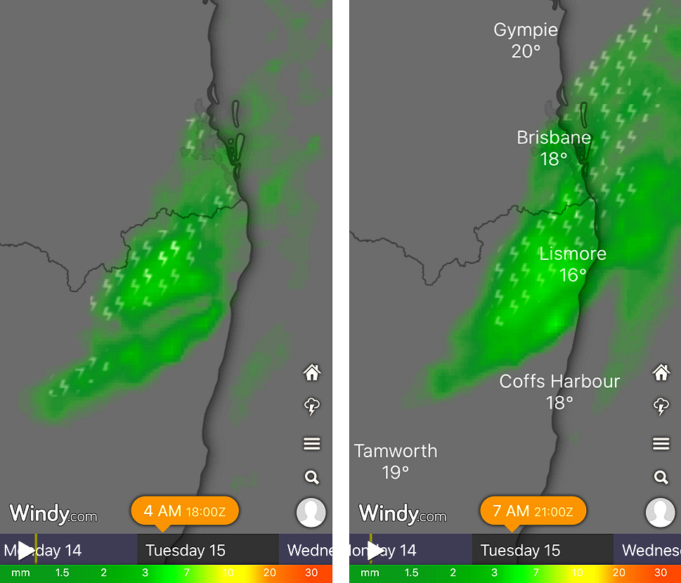 1st graphic above - the EC ensemble's latest suggestion for early Tuesday morning re probabilities of precip between 4am and 7am. 2nd graphic - EC deterministic for 1am-4am and 4am-7am. Early Tuesday morning looks like featuring a small area of localised shower activity in the far SE corner and NE NSW, perhaps even with some thunder (although the latter is a bit less than certain atm). Rainfall amounts don't look impressive at all though, nor long-lasting. Nothing like Fri/Sat. One of the contributors appears to be a small weak low (most noticeable at the surface to 850hpa levels) drifting across inland QLD/NSW border areas that extends up through to the mid levels more as a very short wavelength trough... and a nocturnal low level jet ahead of it which may also help to inject some additional moisture into the region. There's fairly noticeable low level capping around that time so most convection may initiate from mildly unstable parcels rising from somewhat aloft rather than purely from the surface. Wednesday might see some inland locations having the outside chance of a shower or storm. But Thursday's still looking interesting with much stronger instability and shear so wouldn't rule out severe storms somewhere.
|
10 users thanked Ken for this useful post.
|
|
|
|
Rank: Advanced Member
Groups: Registered
Joined: 21/08/2019(UTC) Posts: 185 Location: Ocean View Thanks: 359 times
Was thanked: 539 time(s) in 161 post(s)
|
Great stuff Ken and thank you for the excellent details on why think this things will happen.
|
5 users thanked Pabloako for this useful post.
|
|
|
|
Rank: Advanced Member
Groups: Registered
Joined: 24/08/2019(UTC) Posts: 292 Location: Country Victorian Thanks: 580 times
Was thanked: 503 time(s) in 194 post(s)
|
Thanks for the posts 'guys' Good to catch up 
This is the best l could find from ACCESS r for thursday the 17th oct . A well defined trough line precip' signal on Thursday afternoon. When they are well defined like this l wonder if there will be an obvious cloud front line or perhaps Gust front?
Storms on the BOM forecast for Coolongatta on Thursday with 40% chance of 1mm of rain. I wonder if that suggests dry storms which would not be good for starting fires?https://weathercycles.fi...t-19-trough-line-seq.jpg source http://www.bom.gov.au/au...harts/viewer/index.shtml
|
7 users thanked crikey for this useful post.
|
|
|
|
Rank: Advanced Member
Groups: Registered
Joined: 2/09/2019(UTC) Posts: 105 Location: Brisbane Thanks: 145 times
Was thanked: 561 time(s) in 103 post(s)
|
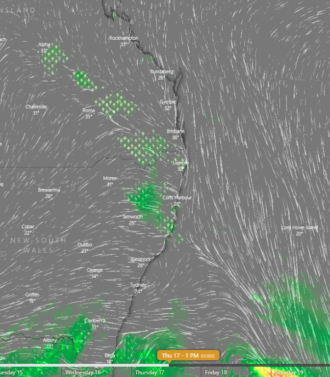   Originally Posted by: crikey Storms on the BOM forecast for Coolongatta on Thursday with 40% chance of 1mm of rain. I wonder if that suggests dry storms which would not be good for starting fires? That's actually a 40% chance of any rainfall rather than a 40% chance of 1mm. The probability figure is always for the chance of any rainfall and is separate from the possible amounts section. Above are some EC outputs. The little lightning symbols represent lightning potential. You can also easily where the front's position is on the wind streamlines maps.
|
7 users thanked Ken for this useful post.
|
|
|
|
Rank: Advanced Member
Groups: Registered
Joined: 15/09/2019(UTC) Posts: 39 Location: Forster NSW mid coast Thanks: 172 times
Was thanked: 135 time(s) in 39 post(s)
|
Some great information there Ken. Thankyou Most interesting I can see a trough coming through NSW on the synoptic on wednesday. Thought l would check out the CAPE (BCSH stormcast)for NSW .Nothing notable but on thursday there seems to be strong CAPE near Brisbane on Thursday afternoon. The lifted index is more widespread which l have posted below 
|
6 users thanked i4hanish for this useful post.
|
|
|
|
Rank: Advanced Member
Groups: Registered
Joined: 25/08/2019(UTC) Posts: 1,839 Location: Ferny Grove Thanks: 985 times
Was thanked: 856 time(s) in 419 post(s)
|
Temperature was rather variable today but close to average day-time temperatures. The dew point have been near average today, rose this morning, more slowly during the day and have been stable since mid afternoon. Near average relative humidity today. E to ENE winds today, ESE to NE from mid afternoon and N to NE tonight. |
|
3 users thanked Falling_Droplet for this useful post.
|
|
|
|
Rank: Advanced Member
Groups: Registered
Joined: 2/09/2019(UTC) Posts: 105 Location: Brisbane Thanks: 145 times
Was thanked: 561 time(s) in 103 post(s)
|
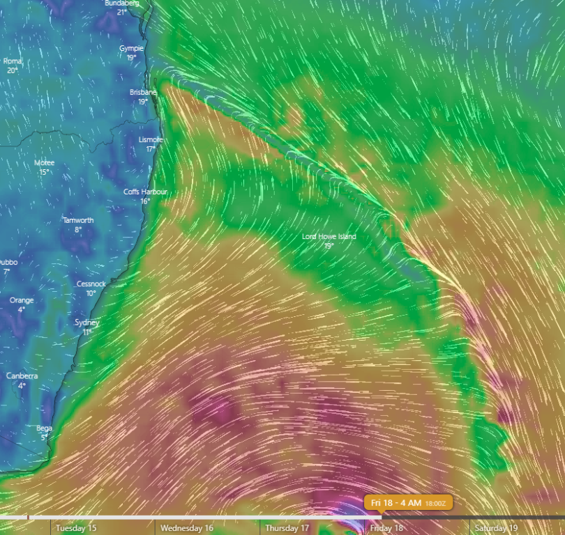
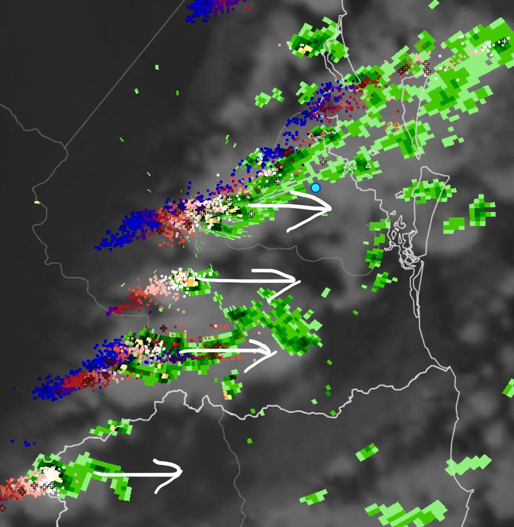 Originally Posted by: Ken Early Tuesday morning looks like featuring a small area of localised shower activity in the far SE corner and NE NSW, perhaps even with some thunder (although the latter is a bit less than certain though). Well the thunder component of that is certain now! It’s 3:15am as I type this and I’ve been enjoying a nice light and sound show here in Moorooka for the past half an hour (and now it’s raining). See above WZ image. The models certainly nailed this activity which suddenly formed albeit with some variations among the models with its northern limit. Edited by user Tuesday, 15 October 2019 3:29:11 AM(UTC)
| Reason: Not specified
|
4 users thanked Ken for this useful post.
|
|
|
|
Rank: Advanced Member
Groups: Registered
Joined: 21/08/2019(UTC) Posts: 182 Location: Wynnum North Thanks: 656 times
Was thanked: 381 time(s) in 167 post(s)
|
WYNNUM NORTH ( 27.4S 153.2E ) - WEATHER
DATE....15 OCT 2019 TIME....0720
CURRENT TEMPERATURE...19.5C
CURRENT HUMIDITY........89%
CURRENT DEW POINT.......18C
CURRENT WIND DIR/SPEED...N 11Kph
CURRENT VISIBILITY.....30KM
CURRENT MSL PRESSURE...1015.3Hpa
CURRENT CLOUD..........3/8 Sc, 7/8 Ac - decreasing.
CURRENT WEATHER......No significant weather
RAIN SINCE 0900 MONDAY...1.0mm
SUMMARY LAST 24 HOURS
YESTERDAY'S MAX TEMP. .......24.4C
THIS MORNING'S MIN TEMP......17.9C
PAST 24 HOURS TEMP ANOMALY..+0.25C
THIS MORNING'S GRASS MIN.....17.8C
AVERAGE 24 HOUR DEW POINT......16C
AVERAGE 24 HOUR MSLP........1016.6Hpa
MAX WIND GUST LAST 24 HOURS....E 32Kph at 1535
PAST 24 HR SIGNIFICANT WEATHER...Thunderstorms started after midnight, ceased around 0400. |
Wyn Nth 2020-Jan165, |
3 users thanked retired weather man for this useful post.
|
|
|
|
Rank: Advanced Member
Groups: Registered
Joined: 25/08/2019(UTC) Posts: 1,839 Location: Ferny Grove Thanks: 985 times
Was thanked: 856 time(s) in 419 post(s)
|
Ferny Grove Weather
Date: 15 Oct 2019
Time: 7:40 AM
Min Temp since 9am yesterday: 16.2 C
Max Temp since 9am yesterday: 26.9 C
Min Ground Temp: 15.2 C
Rain since 9am yesterday: 4.2 mm
Temperature: 18.7 C
Relative Humidity: 89 %
Dew Point: 16.9 C
MSL Pressure: 1015.3 hPa
Wind Speed: Calm
Wind Direction: Calm
Present Weather: State of sky generally unchanged during preceding hour
Visibility: 20km to 39km - Very Good Visibility
Cloud Cover: 8/8
Ground State: Ground moist
Notes of yesterday weather - 14/10/19: A cool morning. The temperature rose briefly at 2 am and was variable in the morning and afternoon. Dew point was near average over the entire day and was stable early in the day, before rising in the morning before rising slower from the mid-morning and stable from the late afternoon. Near average relative humidity. S to SW light winds in the early morning, followed by light and variable winds, E to NNE winds from mid morning, with some E to SE also from the late morning and ESE to ENE in during the afternoon. E to NE light winds later in the afternoon and N to NE in the evening.
Today; Showers and mild thunderstorms in early hours of today with light to moderate falls clearing at 4am. A warm morning. Near average dew point. have been rising. Relative humidity have been near average. Light and variable winds with generally W to SSW and NNE to ENE winds from 2am to 5 am, otherwise calm.
|
|
4 users thanked Falling_Droplet for this useful post.
|
|
|
|
Weather Forum
»
Australia Weather
»
SEQ and NE NSW
»
SE QLD and NE NSW - Day to Day Weather
Forum Jump
You cannot post new topics in this forum.
You cannot reply to topics in this forum.
You cannot delete your posts in this forum.
You cannot edit your posts in this forum.
You cannot create polls in this forum.
You cannot vote in polls in this forum.
Important Information:
The Weather Forum uses cookies. By continuing to browse this site, you are agreeing to our use of cookies.
More Details
Close
