Friday Convective Outlook – SEQ & Northern NSW (GFS vs EC) 13:00 AEST
The latest model runs this morning are showing some disagreement for Friday’s potential storm setup across South-East Queensland and Northern NSW. Here’s what the data currently shows. What I have done is put a simplified technical post followed by my simple version.
1. Model Overview
- GFS has backtracked on earlier stronger convective signals. It’s now showing a dry mid-level profile with limited instability — only weak inland convection possible.
- EC remains slightly more bullish, hinting at isolated storms Friday and potentially ramping up instability through the weekend, especially Saturday–Sunday, as deeper moisture returns.
Simple version:
GFS has pulled back on storms for Friday, while the European model (EC) still thinks a few might develop and become more active over the weekend.
2. Sounding Analysis – Friday 13:00 AEST
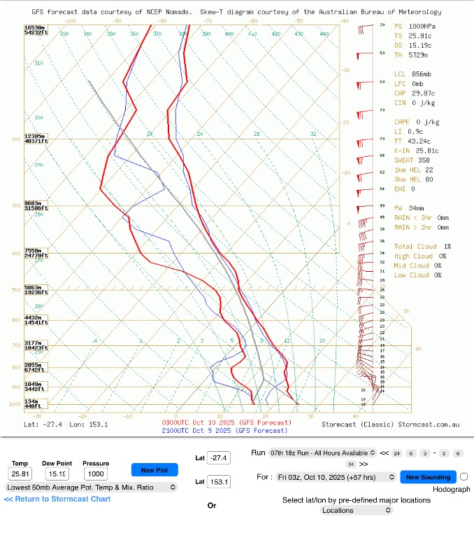
Brisbane
- CAPE: ~1 J/kg (essentially nil)
- CIN: ~340 J/kg (strong cap)
- Profile: Pronounced dry slot between 700–500 mb, no meaningful instability or lift.
- Outcome: Capped, stable atmosphere.
Plain-English: Air is too dry and stable — no storms expected near the coast.
Toowoomba
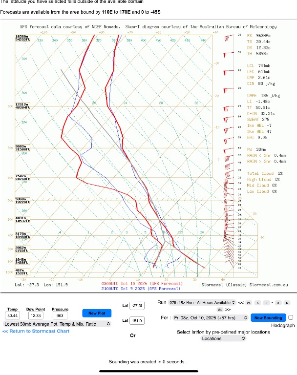
- CAPE: ~186 J/kg
- CIN: ~83 J/kg
- LCL: ~740 mb – high-based
- PW: 33 mm – slightly better moisture than coast
- Profile: Still quite dry aloft, weak instability, minimal shear support.
- Outcome: Small window for isolated high-based convection late afternoon if surface heating is strong enough.
Plain-English: Toowoomba has a tiny chance of a dry, gusty shower or weak storm — but it’s a long shot.
Dalby
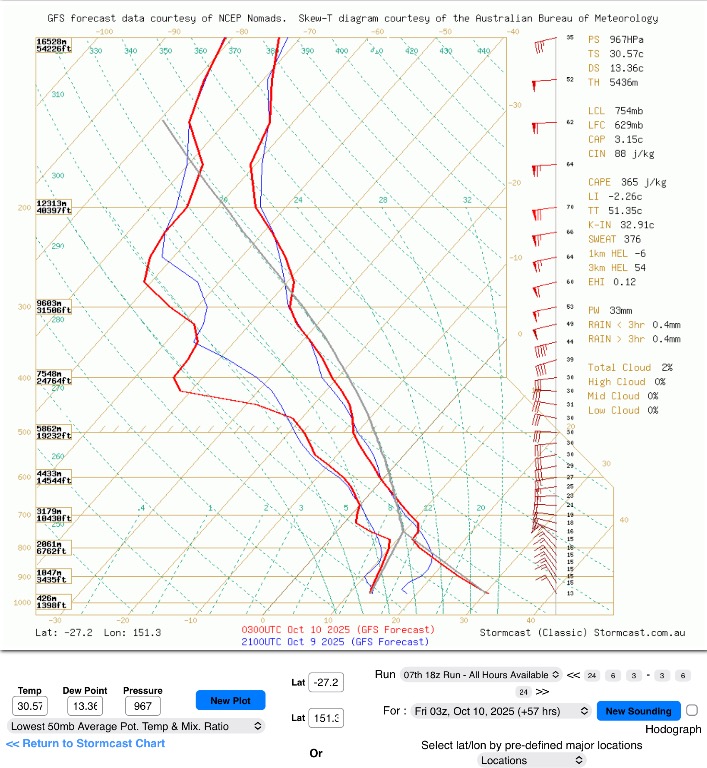
- CAPE: ~365 J/kg
- CIN: ~88 J/kg
- LCL: ~754 mb
- PW: 33 mm
- Profile: Similar dry layer mid-levels but marginally better instability inland.
- Outcome: Slightly more favourable for an isolated, short-lived storm.
Plain-English: Inland near Dalby could see a weak storm if conditions line up — 20–30% chance, mainly late afternoon.
3. Pattern
There’s a clear dry intrusion in the mid-levels cutting off deeper convection across SEQ.
The cap is strong east of the ranges, so updrafts will struggle to initiate.
Even if convection fires inland, the high LCLs suggest any storms will be high-based and short-lived, possibly producing dry lightning or gusty outflows rather than heavy rain.
Simple version:
The air higher up is too dry for healthy storms. Even if a few form inland, they’ll probably collapse quickly with gusty winds and little rain.
4. EC Comparison (Weekend Outlook)
- EC continues to signal moisture recovery and increased instability Saturday–Sunday, especially over the Darling Downs and Scenic Rim, with some potential for stronger or even severe storms by Sunday if surface dew points rebound.
- GFS lags this trend, still keeping dry mid-levels into Monday.
Simple version:
If EC is right, we’ll go from dry and stable Friday to much better storm potential over the weekend. GFS is slower to bring that change.
5. Summary / Probabilities
Friday looks mostly quiet storm-wise under GFS guidance — maybe a few high-based cells inland if heating pushes through the cap.
EC hints that things could change quickly into the weekend with deeper moisture returning, so it’s worth keeping an eye on updates over the next two runs.
So basically in a nutshell, Friday is likely too dry for decent storms around Brisbane. Toowoomba and Dalby have a small chance of weak, dry ones. The better storm days could be Saturday or Sunday if the European model is right and moisture returns
So it is really a wait and see how the next couple of runs goes — this setup could still swing either way if the moisture returns.
Fire Weather Note:
While a few high-based or dry storms could develop inland on Friday, these types of storms are unlikely to bring meaningful rainfall. Instead, they can produce dry lightning and gusty, erratic winds — both of which can easily trigger or spread bushfires under current dry conditions. If you’re in or near active fire zones, keep an eye on local warnings and be aware that these storms can look promising on radar but deliver little or no rain to the surface.
As I said earlier, EC, over the week end did look a bit more generous but it is a wait and see.
Cheers.
Colin
